Tuesday 18th June

Campeltown has a working harbour. Yachts have to moor out of the harbour to one side (on the right). Felled trees were stacked up on the harbour wall, ready for shipping out.
We awake rather late, having caught up on our early start from Northern Ireland yesterday and take a leisurely breakfast before walking to the local swimming baths for a “yachtsman’s shower”, there being no amenities provided by the Campbeltown Berthing Company who administer the yacht pontoon. The shower facilities turn out to be adequate but basic and we are soon done. Campbeltown is the first place on our travels that Yvonne has felt uncomfortable walking around on her own so it was a useful staging post but nothing more. The Royal Yacht Squadron has moored along the pontoon from us to the delight of some of the locals but we don’t know our celebs well enough to recognise anybody (and they don’t seem to recognise us!)
The Firth of Clyde is one of the UK’s great cruising grounds, combining good access from the sea and land, some glorious scenery, plenty of options and space around the lochs and islands and some excellent sailing and all within a set of sea lochs with almost inland sailing conditions in many parts. We have three days to explore this area before we collect our friend Janet from Ardrossan. We decide to go to Lochranza on the northern end of the Isle of Arran.
We depart just after 11:00 in pleasant sun and a light breeze so we can sail out of Campbeltown Loch and up Kilbrannen Sound with the Mull of Kintyre on the west and the Isle of Arran on the right. (For the record, a loch is open to the sea at one end; a sound is open at both ends. We are led to believe that anchoring can be charged for in a loch but not a sound – we shall see!).

Sailing past the Isle of Arran with spinnaker set and the sun shining. If only it could always be like this!
We are able to set the spinnaker and it is a pleasant, easy sail using the autohelm for the most part. The Isle of Arran is good scenery to sail past, being very mountainous with peaks reaching up to 857 m (over 2800 feet). Habitation and communications are generally round the edge with much of the interior comprising of rugged hills and craggy peaks.
When the sun shines, the light is remarkably soft around here. It is not the only place by the sea which gives this effect by any means but it gives the area a special quality.
The water in this area is generally very deep. Our depth meter stops at around 100 m; the depths we encounter in the Firth of Clyde are often greater than this, a result no doubt of ice age glaciers grinding out the rock. These depths compare markedly with most of those we have encountered so far, which rarely exceed 50 m and for large areas of the Irish Sea are somewhat less for considerable stretches. It is little wonder that the Firth of Clyde and its approaches are a favourite area for submarine training.
The geology around here is varied and interesting too. We don’t pretend to understand it by any means but as we sail past Arran we can see sandstone, granite and various other rocks. Away to our south is the island of Ailsa Craig, which is a domed shaped island and apparently the granite plug to a long extinct volcano. Nowadays it is home to thousands of gannets and its stone is said to make the finest curling stones.

Lochranza with the ruined castle at the waters edge and the high mountains of Arran poking over the hills
The winds come and go but we are able to sail most of the way and reach Lochranza around 5 pm in time for tea and cake, admiring the scenery around us. We take some photos but it is difficult to take good photos of landscapes that truly portray the scene with our simple camera as they all tend to become lines of land with much sea in the front!

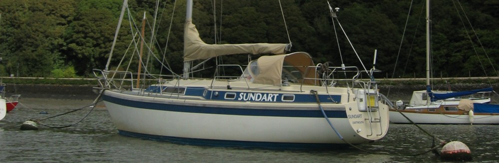
Sundart at the moorings in Lochranza as viewed over the garden of the Lochranza Hotel
Yvonne remembers Lochranza from 30 years ago as a quiet place with a few boats moored and plenty of space to anchor. As we round the corner into the Loch we see this is no longer the case as the bay is largely laid with moorings and there are plenty of boats. Such is the march of time and the increase in wealth and boat ownership! We moor up to a buoy near to the landing place and pontoon as we have decided to eat ashore this evening. According to the pilot book there is one hostelry – the Lochranza Hotel so we will try our luck there.

The Lochranza Hotel
The rubber dinghy is blown up and the little outboard carefully attached then we set off to the shore. The pontoon makes an easy landing with no need to go paddling and the dinghy can be left afloat tied to the pontoon.
Lochranza is an attractive village strung out along each side of its loch with a ruined castle overlooking the loch (relic of when the area was owned by a local laird who would receive his tithes and dispense his justice).

The Dutch trio at the Lochranza Hotel
We soon come across the Hotel, a pleasant looking building with a colourful garden and venture in. Although it has only just gone 6 it is already busy with locals and visitors and we take the last table with a view across the loch. The beer is good and we order Lochranza sausages and venison pie which are excellent. Whilst we are eating a trio start playing lounge jazz in one corner of the bar – clarinet, guitar and accordion. It turns out that they are Dutch – husband and wife plus friend, who are touring Scotland, offering to play in the various bars and hotels they stay at. Apparently, the reception has been very warm across Scotland and no wonder – they are very entertaining with an excellent command of English. We have been fortunate to come across them as they are excellent and along with the rest of the clientele we enjoy their playing. The bar man, however, looks dour throughout. Next to us a Scots lady enjoys a plate of chips with melted cheese and white bread and butter. Some other locals start dancing and foot tapping. Seems like we are getting our full dose of stereotyped Scots this evening!
The music ended, we leave the pleasant atmosphere at the hotel and walk along to view the castle then back to the boat, the rubber flubber is packed away and we plan tomorrow’s trip to the Kyles of Bute.
Ships log
Days run: 20.5 nm
Total mileage to date: 837.7 nm
Engine hours today: 2.0
Hours sailed today: 6.0
Total hours sailed: 186.1
Wednesday 19th June
We set our alarm so we don’t lie in and breakfast on deck before sailing off our mooring at around 9:30. It is a lovely sailing day – sun, steady breeze in just the right direction and the prospect of sailing through some of the best scenery in this area. Once outside the loch, we set course and hoist the spinnaker, enjoying one of our best ever sails in fine conditions. This is what we ordered!

View up the Western Kyle of Bute with the village of Tignabruaich on the left, island of Bute on the right and Loch Riddon ahead. The village developed as a tourist centre when the Clyde steamer service started up in the 19th Century.
The Island of Bute is much lower than Arran and is set close into the mainland with a relatively narrow channel round its north end and long sounds each side which are known collectively as the Kyles of Bute. The beauty lies in the surrounding hills and lochs that branch off the main waterway.

Rhododendrons provide a stunning display of colour up the hill sides in June. These plants are gradually invading the indigenous plants domain. There are many fine houses up the Kyles, many dating from Victorian times and generally kept very smart with well-tended grounds. There must be some quiet wealth here.
Once into the West Kyle Sound we change to the two “working” sails (genoa and mainsail) as we are sailing at a different angle to the wind and there are occasional gusts of wind coming down the hills and valley at different directions so we can handle those better with the working sails. We have a good sail up the Sound and decide to pick up a mooring for a lunchtime stop which we do off the villages of Auchenlochan and Tighnabruaich: the first mooring is on poor state with a rotting mooring warp so we try another.
Later, we sail on, eventually having to motor as the waterway narrows and the wind becomes unpredictable. There are many fine houses along the mainland side of this loch and there are glorious swathes of pink and mauve rhododendrons up some of the hill sides. Some people around here regard these plants as foreign weeds as they spread steadily, supplanting the indigenous flora but they look tremendous from the water. They were introduced from the Himalayas in the 19th century as part of the development of this area as a tourist resort when the steamer service opened up in the Firth of Clyde.

Dusk at 11 pm: the view from our anchorage at the Kyles of Bute towards Loch Riddon
We have a look into Loch Riddon and then anchor in a quiet pool behind the Burnt Islands at the heart of the Kyles of Bute. The views are splendid – it is hard to imagine that we are not so far from Glasgow. Yvonne remembers the jelly fish from her previous visit and sure enough, there they are as we anchor, but what little tide there is wafts them away and soon the water is clear. A couple of other boats share our little bay at anchor but all is generally calm and peaceful. We enjoy a quiet gin and tonic – the sun is well over the yard arm and it is turning into a warm summer evening.
Over on one of the islands there is a big gull colony – very noisy neighbours for a time! We cook potato cheese and onion pie and bacon for supper which we eat in the evening sun in the cockpit. The gulls must have incredibly sharp senses as they detect our bacon rinds and come over mob handed to swoop on the rinds, picking them off the water.

Half moon at neap tides reflected in the still water at our anchorage in the Kyles of Bute
We are nearly at latitude 56 degrees north, There is plenty of light in the sky even at 11 PM. A half moon rises and is reflected in the still water. It is neap tides and there is very little tidal movement here.
We sleep well.
Ships log
Days run: 27.7 nm
Total mileage to date: 865.4 nm
Engine hours today: 0.8
Hours sailed today: 5.4
Total hours sailed: 191.5
Thursday 20th June
Our plan to-day is to sail down the east side of Bute, into Bute Sound and to anchor off the little town of Lamlash on the east side of Arran, in the shelter of Holy Island. The inshore weather forecast from the met Office that has come in over night on the Navtex gives force 3 to 4 occasionally force 5 south-east winds, becoming force 3 to 4 variable later. In reality it is grey, misty and with hardly a breath of wind. Clearly the met office is having a problem forecasting accurately when there is a high pressure system around plus a low to the south of us, the movements of which are hard to predict. When we can get a signal, we try to download the weather map and alternative forecasts via the laptop so we can make our own mind up but we cannot do this today so have to rely on the one forecast.
(The Navtex is an instrument that we leave switched on all the time. The Navtex is a world wide system. In the UK its long wave signals are transmitted at pre-ordained times every day from one of 3 stations around the country. It is possible to programme it for what information is picked up and which stations are used, depending on the area we are in. We always select the weather (which is provided by the Met Office) and for a trip such as this go for the inshore forecast which covers the coastal areas up to 12 miles off-shore. We decline things that are of no interest including piracy reports!).

The mountains in the centre of Arran dominate almost every part of the island, in this case Lamlash as viewed from Holy Island across an anchorage big enough for a fleet of warships.
We raise the anchor and motor sail down the East Kyle. The weather remains misty, sultry and windless for most of the day so we end up motor sailing the whole 28 miles to Lamlash. On the way we have a look into Loch Striven, which our pilot book describes as “a bleak and rather featureless loch” but which was where the midget submarines crews trained in WW2 which were used on attacks on the Tirpitz in Norway. Today’s sail is a complete contrast to yesterday, with only the odd coaster going past, bound for the Clyde and some land marks on the misty distant shores.

Anchored off Holy Island, opposite Lamlash in the Isle of Arran. A community of Tibetan monks live here, sharing the island with feral ponies, sheep and goats.
In due course we arrive at Lamlash and after a cursory motor past the town we anchor on the other side of the bay in the lee of Holy Island in calm water. The sky is slowly clearing and there is a little breeze, lifting the overcast at long last and giving us a good view across the bay towards the distant mountains. It is warm and we sit outside int he cockpit until darkness, when the moon comes out and is reflected off the still water.
Ships log
Days run: 28.3 nm
Total mileage to date: 893.7 nm
Engine hours today: 6.0
Total engine hours to date: 116.8
Hours sailed today: 6.0
Total hours sailed: 197.5
Friday 21st June
We awake to grey skies and clouds covering the higher peaks of Arran. A small wind has sprung up from the west, swinging us round in the night and making the anchor chain rumble as it takes up its new position. Breakfast done, we sail off the anchor (which we practice from time to time in case the engine ever fails) and set sail to Ardrossan about 15 miles away for a “pit stop” to stock up on provisions, do our washing, have a shower, get rid of our rubbish (it is surprising how it builds up on a boat) and meet our friend Janet who will be with us for the next week or so. Unlike previous days, the water is choppy with little confused waves and the wind comes in different strengths and directions, partly due to the mountains around us and partly due to a forthcoming change in the weather. This makes the sail more strenuous as we have to keep adjusting the sails but in due course the wind settles down to one direction and strength and we make good progress. We steer round a few trawlers and a large sludge ship going up to Glasgow.
As we reach Ardrossan and are taking our sails down we see the “Cal Mac” (Caledonian Macbrayn) ferry from Arran closing in on the harbour entrance so we give way to “might” and follow them into the harbour. Once again, we find the marina has been laid in the old fishing harbour, Ardrossan’s fishing fleet having almost totally disappeared. Although marinas don’t provide the employment that the old fishing industry used to , they must make a significant contribution to the local economy by way of fees plus the inevitable boatyard, chandlery and service industry.
Ardrossan harbour is well served: Asda have built their supermarket within 100 yards, the laundry and shower arrangements are good. Even the railway terminates right on the harbour wall (Ardrossan having kept its harbour rail link to connect to the Arran ferry) so Janet can walk right off the train and onto Sundart.
Over supper we plan our next step, which is to sail to Tarbert in Loch Fyne, then Ardrishaig to enter the Crinan Canal which will provide a short cut to the Western Isles and the North of Scotland, However, the weather is breaking with a large low pressure system coming in from the Atlantic so we will need to have a look again tomorrow before finalising our plans.
Ships log
Days run: 14.6 nm
Total mileage to date: 908.3 nm
Engine hours today: 0.8
Total engine hours to date: 117.6
Hours sailed today: 3.0
Total hours sailed: 200.5
Fair winds to you all
Yvonne, Janet and John
