Thursday 6th June – a windless trek to the Isle of Man
The gate to the Fleetwood lock opened at around 0915, releasing us from the marina to sail to the Isle of Man. There was very little wind so we motored out and hoisted the main sail. (Setting the main sail whilst motoring normally adds about half a knot to our speed due to the forward motion from the engine filling the sail giving it some drive – this is a strange effect but it works!). In the distance we could see the Heysham nuclear power station. This one power station contributes about 20% of the installed capacity of all the UK wind farms combined. (Wind farms never achieve all their installed capacity due to the variation in the wind. In addition, in our travels we have never seen an off shore wind farm with all the rotors turning, leading us to wonder at the reliability of these installations).
We headed towards Douglas on the Isle of Man, passing numerous wind farms plus gas and oil platforms in Morecambe Bay. We saw at least two new jack up drilling rigs plus survey ships, presumably getting to grips with new gas finds which can be exploited as a result of the government’s decision to allow “fracking” to continue.
Once the Morecambe bay area was left behind the journey became pretty featureless. We put the auto helm on and read and relaxed, keeping an eye out for any shipping whilst the engine chugged away and the auto helm did the work for us. We were in the middle of high pressure weather which means settled, fine and dry weather but rather misty, so we didn’t see the Isle of Man until we were about 4 or 5 miles away (on a clear day we can see land from 15 or even 20 miles out).

The water front at Douglas with the castle in the middle. The town is set around a fine bay with lights and a horse-drawn tram running all round the bay. The place is alive from end to end with a carnival atmosphere during the TT racing week.
Eventually,around 7:30 we arrived at Douglas to find a large cruise liner anchored int he bay. Douglas is the commercial port and centre for the Isle of Man. The port is squeezed into a relatively small area to accommodate the ferries, cargo vessels, fishing boats and leisure craft so all vessels have to report in to Port Control before leaving or entering.

Douglas is the commercial port and centre of the Isle of Man with ferries and small boats crowded into a relatively small area. The entrance to the inner harbour where we moored is on the left past the yachts moored up.
We were held in the bay for about half an hour whilst a fast catamaran ferry and the cruise ship depart. It was interesting to hear the port control conversations with these ships, including how many crew and passengers they have on board and where they are bound for.. Whilst waiting we can hear loud music from the shore and can see lights and crowds of people along the water front – Douglas is in carnival mode as it is the TT race week.
We wanted to moor in the inner harbour for ease of access to the town but had to wait for the tide to rise to access this area over the flap sill system that stops the inner harbour drying out at low tide so we moored up near the lifeboat slipway and had our supper. At around 9:30 we were called by port control over our VHF radio. Entry to the inner harbour requires a lift bridge to be opened, stopping a major traffic route so times are strictly rationed when this is done.

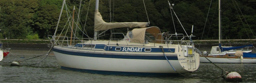
The inner harbour at Douglas as seen from the lift bridge with Sundart moored closest to the camera. This is right in the heart of Douglas.
The inner harbour was packed out but we took the place of a boat with four young Irishmen who were leaving. We moored, and then they had second thoughts as they were short of a life jacket and asked if we would sell them one. No joy, so they moored against us and went in search of the elusive life jacket before they set sail. The boat only had one (tatty) sail and the crew were in T-shirts and shorts. They had borrowed the boat to come to the TT races and needed to return it to Liverpool the next day. We gleaned information on the TT races from them and they kindly give us their marina gate access card. Eventually they found a life jacket to buy and departed – we assume they made it to Liverpool!
Yvonne was tired and retired to bed but John was curious so had a walk around town. There were big crowds partying away with a live (free) band, a fun fair, bungee jumping from a platform suspended from a crane and who knows what else!
The Isle of Man is a well-known tax haven but unlike, say, the Channel Island towns of St Peter Port or St Helier, Douglas seemed on a brief walk round to be just a little bit tatty. There is no doubt much wealth here but it does not show in the form of many smart buildings. What was evident is an apparently strong identity with links to the other Celtic “nations” – there were numerous Manx flags and composite flags incorporating the Manx, Cornish, Irish, Welsh, Scots and Breton flags. Douglas is also the home of the oldest continuous seat of government (the Tynwald) which goes back over a thousand years to the Viking invasions – older than the Atheling in Iceland which they claim is the oldest. Many of the roads have dual names in English and Celtic.
Ship’s log
Distance sailed today: 55.5 nautical miles
Total distance sailed to date: 642 nm
Engine hours today: 10.6
Total engine hours to date: 81.4
Hours sailed today: 11.0
Total hours sailed to date: 141.5
Friday 7th June
We decided to see the TT racing so after paying our harbour dues and booking our fuel card (more on that later) we were given a map by the chandlery and walked the mile and a half or so to the nearest point on the circuit. Today was finals day.

The Isle of Man TT racing as seen from Quarterbridge. The bikes were moving so fast that our little camera could not catch the action. At this point the bikes are just slowing down from descending Bray Hill at up too 180 mph. Later that day a super bike skidded off this corner, injuring 10 spectators and stopping racing for over 3 hours
The TT races were established in 1907 and have a fearsome reputation as probably the most dangerous race circuit in the world – over 200 riders have died on the 37 mile mountain circuit that takes in the streets of Douglas, open roads across the island and the twisting roads through the mountainous interior. (A Japanese rider died this year during practice). The thrill for spectators and riders is the raw racing that this circuit provides; the numerous good viewing points and the sheer thrill of out-and-out road racing plus of course the camaraderie of like-minded people. There must be thousands of people who come to the races each year and the island goes into holiday mode, with quite a number of businesses shutting for the week. We met people or saw motor bikes from many countries particularly Ireland and Germany as well as the UK.
We watched the “lightweight” bike final – up to 650 cc we believe. During the race the circuit record was broken twice with an average speed of over 119 mph! We viewed the race from Quarterbridge on the outskirts of Douglas, where riders descend Bray Hill at speeds of up to 180 mph before braking to turn sharp right at the crossroads. We sat on a bank on carpet tiles, out of the “line of skid” of the race course. Our little camera (and its operator) could not keep up with the speeding bikes – it took John 4 attempts to capture a picture of a bike, not just its shadow, and then it was too blurred to use so the only photo we have is of a bike fast receding into the distance!
We had to leave before the senior race for the 1000 cc super bikes in the afternoon as we wanted to catch the lock out of the harbour before low tide. There was in fact a crash our corner with 10 spectators injured and the race held up for 3 hours so we were fortunate. As it was, we did a quick shop on the way back and got out on the last lock out of the day.

Fuelling up can be a challenge as many of the fuel berths are designed for much bigger fishing boats than Sundart. This is the fuel berth at Douglas – self-service from the fuel pump on the harbour wall using a card system once you have climbed the ladder up the harbour wall.
We had previously arranged to top up our diesel in the outer harbour using a pre-paid card system. Re-fuelling can be quite a challenge as many fuel berths are made for much larger boats, typically large fishing boasts. In Douglas we had to tie the boat to a large chain and climb up a vertical ladder up the harbour wall. The pump was a self-service type with an enormously long hose to reach down to our little boat. Very different from the short little pipes at garage forecourts!
Once refueled we were cleared by port control and sailed out on a light breeze for Port St. Mary in the south of the island. Once we left Douglas we could view the island from the sea. The Isle of Man is surprisingly mountainous with peaks reaching up to 617 meters (2000 feet). Much of the terrain is similar to Wales or similar areas with stone walls and rocky cliffs at the sea. After a gentle sail down the coast we picked up a (free) mooring buoy in the bay at Port St Mary but decided against going ashore as that would have meant getting the rubber dinghy out late in the evening.
Ships log
Distance sailed today: 13.1 nautical miles
Total distance to date: 655.1 nm
Saturday 8th June
Another lovely day – how long can this last?! John did the full engine checks. We decided to go round to Port Erin on the southwest side of the island as we heard it is a pleasant bay and town. To do this we needed to pass through the narrow passage between the main island and the Calf of Man as this cuts off a long sail round the bottom of the islands and avoid some potentially rough “overfalls”. Timing is critical in these passages as one needs to transit the narrowest stretch of water around slack tide to avoid turbulence and the strong tidal runs. In the event, we sailed off the mooring buoy and round to the passage, arriving there just after slack water so Sundart sped through without difficulty. Once again, we tracked our progress on the Navionics software we have on our Samsung tablet backed up by cross checking against the paper chart

Port Erin is a delightful, traditional small seaside resort town in the south of the Isle of Man with a big sandy beach, a little harbour and no tat. We used the free moorings in the middle of the bay to the right of this photo
We soon reached Port Erin and tacked into the bay, picking up the last remaining free mooring by the life boat station. The town was several hundred yards off but as the tide dropped a big sandy beach grew out towards us. We got the rubber dinghy out and fitted the little outboard as the trip ashore was a rather too far to paddle and contrary to the weather forecast there was a bit of breeze.

Port Erin beach
We landed at the nearest steps on the harbour wall and left the dingy afloat; tied to a bollard, using the longest line we had as the tide was going out to avoid drying the hanging by its mooring rope when the water receded.
Port Erin is a pretty little resort town with a wide sandy beach and houses dotted round the steep sides of the bay. We walked along the beach and into the town in the warm sun to pick up a paper and an ice cream (it’s summer after all – at least for now). We sought the local tourist information office but being Saturday it was shut – on what must have been one of their busiest tourist days!

The Isle of Man is a transport connoseurs delight. This is the Isle of Man Steam Railway. The IOM government has taken it over to preserve the one line that remains open from Douglas to Port Erin.
John was delighted to see the Isle of Man Steam Railway terminus complete with steam train and museum – Yvonne thought she had left all that behind at Ffestiniog! (The Isle of Man is a transport buffs delight with 3 steam railways, an electric tram from Douglas along the coast to Ramsey, a Railway up Snaefell, the tallest mountain on the island and horse drawn trams in Douglas to name but a few attractions. Most of these date from the Victorian age when the IOM built up its tourist trade mainly from the north west of England, Scotland and Ireland.

The IOM steam railway is lovingly maintained

The IOM steam railway is lovingly preserved, including its Victorian locomotives, rolling stock and stations
They are all lovingly looked after and maintained using workshops on the island).
After eating our lunch on the cliffs overlooking the beach we took a walk around the bay along paths cut into the hillsides. For the most part Port Erin is well presented and kept, although there are a few hotels that have shut and some that have been converted into flats – a sign of how hard the UK tourist areas have to work these days. We enjoy a cup of tea and cake at a café with a glorious view, and then return via the town to buy & post some cards before returning to the dingy – just in time as it was at full stretch on its mooring line!
Back on Sundart we enjoy the Sunday papers in the sun before cooking supper and planning our journey tomorrow to Northern Ireland.
We have enjoyed our stay on the isle of Man. Douglas and the TT races were “full on” but there is so much more to the IOM as typified by our visit to Pert Erin and sails along its lovely coasts. It would be worth another visit.
Ship’s log
Distance sailed today: 6.3 nautical miles
Total distance sailed to date: 661.4 nm
Engine hours today: 0.5
Total engine hours to date: 83.9
Hours sailed today: 1.5
Total hours sailed to date: 146.5
Our charity
This week the total raised through our website to date has gone over the £2000 mark (including Gift Aid) for our chosen charity SUDEP Action for research into epilepsy. Our sincere thanks to all who have donated to this most worthwhile cause. We will, of course, keep the web page for donations open for quite a time so we are hopeful that we can keep the ball rolling and continue to increase our funding for research into this difficult and little understood disease.
 Fair winds to you all
Yvonne & John
